It’s been a long time since I’ve been above the Mason-Dixon Line. My family and I stayed the month of July 2025 right north of it. We crossed the line regularly during the month we stayed in a rental house in-between the little towns of Meyersdale and Berlin, PA. The house is in Somerset County, a rural area hours away from any big city. At first glance it’s not a likely place where traveling Texans would lay their heads for a month. When our travels came up in conversation folk tend to ask along the lines of, “why are you staying here of all places?” Summer and I learned the easiest explanation is, “we kinda threw a dart at a map and landed here.”
The longer explanation is that throughout our trip we’ve booked places we could afford along with the mortgage we are trying to unload back in Texas. We looked at rentals offering a reasonable monthly rate in an area we kind of want to stay and narrow in on something that’s at a price range that seems reasonable. Our stay in Somerset County was a little different though. My last couple of semesters in grad school, before we started this cross-country jaunt, I made a point to meet with my professors. One of the questions I would ask was, “if you could go anywhere in the U.S. to stay for a month where would you go?” My architectural history professor Peter Dedek mentioned Cumberland, Maryland due to its interesting architecture.
The area around Cumberland seemed like a reasonable place to start an extended nomadic adventure. We found our rental house in Somerset County, Pennsylvania about 35 minutes north of Cumberland across the Mason-Dixon.
Intellectually, I understood that Appalachia stretched beyond the southern United States and into the northeast. I heard the Appalachians were, during the time of Pangea, the same range as the Highlands of Scotland and the Atlas Mountains of Morrocco. I could see on a map, the Catskills of New York and the Green Mountains of Vermont were part of the larger Appalachian range. I just never thought of the mountains north of West Viginia as the same mountains that my ancestors moved out of in covered wagons, leaving Tennessee as they pushed into and colonized East Texas. But Appalachia they are, and we connected with their ancient beauty over the next few months from different vantages. The mountains in the chain we stayed near in Pennsylvania are called the Alleghenies. The name evokes in my mind visuals from Allan Eckert’s book The Frontiersmen.
The area we first called temporary home is referred to, tongue-in-cheek by the locals, as “Tri-State.” Their Tri-state is where the borders of Pennsylvania, Maryland, and West Virginia meet. That land is historically and culturally rich and we had a great time for that month of July.
The house we rented is on a farm in a valley between two ridges of the Allegheny Mountains in an area called the Brothersvalley Township in Somerset County, Pennsylvania. The view from the front porch is a sight to see. It’s a lovely area, rolling hills of land under harvest, covered in crops in the colors of July. Every shade of green, gold, and violet in fields arrayed in lines and rectangles. Colorful hills of cropland stretch out into dark greens and browns of forested tall ridges capped by a dozen or so towering wind turbines, their slow cycles harvesting wind with massive blades that cut silently through low clouds and fogs that roll into the little valley that farming families call home.
The whole of this Tri-state was once very active in coal mining and lumber. Apparently hills were taller and forests fuller before both were hacked away to fuel industrialization. I could picture the land from times before in the pockets of preserved forests and the names of roads and locations. One example was the Belin Plank Road, I was informed by a local history buff that the road was once actually made of wooden planks. The former wealth of the land is apparent in many of the old buildings that stand in honorable and steadfast architectural styles that vary through a limited stylistic era, before industry exhausted the area and went further west in search of fuel to fill its endless hunger. Churches and some of the other important town buildings are cared for and looked after, even through the toughest times.
Many of the houses were old but maintained. The small towns are well kept and driving from one town to another you will spot lonely, beautiful churches still used by farmers on Sundays, surrounded by seemingly endless fields. On HGTV they talk of houses with “good bones,” the towns of Somerset County have good bones in spades. Their days of affluence when the stone churches and the brick homes were built are behind them, the future seemed caught in some space between hopeful and uncertain as we traversed the roads and crisscrossed up and down the Mason-Dixon.
One historic feature that dominates the history of the area is the National Highway. Now, mostly two-lane thing, which stretches from Cumberland, MD to Pittsburg, PA and beyond, was once a path cut through a dense forest intended to get a band of British troops to siege a French fort. It was carved out by humans under the command of long dead generals in a war that some claim to be the first global conflict. Summer and I had our sixteenth anniversary out on the National Road, or Braddock’s Road, or the place of George Washington’s early speculative investments[1], however you like. Before dinner we visited Fort Necessity National Battlefield where a young Colonel George Washington fought and lost, his soldiers firing out the first shots of the Seven Years War.
There are old inns that dot the old road that have been giving quarter, rest, and ale to wary travelers since the road became “pacified” through investment of luminaries like Washington who remembered the site of his first fame, or infamy[2], and marked the road he helped carve out for future investments. We had dinner as a family for our anniversary in one of the inns, apply named The Old Stone Inn. It was the kind of place you knew was haunted, not just by the ghosts of history but if the waitresses and workers are to be trusted, by spirits that wish to remain in the consciousness of those who still alive and kicking.
Old bridges, ancient toll booths, grave sites, and unquieted memories dot the landscape everywhere you look around these parts. It is a place where the past is still very much alive and the future is something that is distant and to be weary of.
In the next installment, I will talk a bit more about the region, the sites we visited, and the people we met. From visiting not one, but two, homes designed by Frank Llyod Wright, making an unexpected pilgrimage to the Flight 93 Memorial, Cumberland, Frostburg, Sommerset, the land of diners, quilt patterns, battlefields, Confederate flags, and the welcoming flicker of candles in the windows of Pennsylvania Dutch homes.
[1] Washington was tasked to help carve a road out of the wilderness, straight through from Cumberland to what is now Pittsburg. It was a densely forested region at the time. During his time in that once wilderness as a young British officer, he took note of the rich opportunities that lay not just in the region but along such a potentially profitable road connecting the headwaters of the Potomac in Cumberland to the Ohio River Valley. His lobbying and monetary speculation are paramount to that road becoming the first highway paid for and maintained, for a while, by the national government. It is a fascinating history and one which the Fort Necessity National Battlefield does an incredible job of interpreting. Worth a stop, considering it is right down the road from Wright’s Fallingwater.
[2] There is a great controversary of Washington’s assassination of a French officer sparking the first shots of the Seven Years War that is worth further investigation for any history hounds out there.
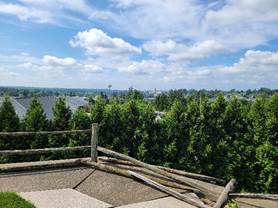
Figure 1: View of the Somerset, PA courthouse from an old Georgian Estate now part of a shopping center know as Georgian Place.

Figure 2: Credit to Summer, sign reads “The First Iron Rails”. The old railroad is now an amazing bike path called the Great Allegheny Passage or just the GAP.
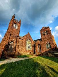
Figure 3: Credit to Summer, Church in between Meyersdale and Berlin, PA

Figure 4: Ft. Necessity, the museum is great, the fort recreation is interesting to see the small scale of such an important event.
